Submitted by : Alok Vyas
Master of Urban Planning
Fall Semester 1999
Date: December 13, 1999
Urban Planning 579/ Natural Resources & Environment 579
Land Use Planning & Design
Professor Donna Erickson
University of Michigan
West Branch Fleming Creek Land Use Development Plan
Years 2000-2010
I am pleased to present this report for the new Land Use development plan for the West Branch section of the Fleming Creek Watershed Area. In this report, you will find the following order of development strategies for the proposed land use.
I. Existing Inventory of Land Uses:
Field Trips to the Watershed area produced a list of observations that are enumerated in this section. This includes properties, features and institutions that were distinctively observed.
II. Data Collection, Analysis and Preparation of Maps:
This section deals with accessing different maps, recording their features and analyzing and comparing each of them with respect to the other maps. The process involved overlaying different maps on top of each other and tracing out their common features and designs. There were three maps created in the preliminary stage with a final (fourth) one showing the proposed land use development.
III. Land Use Development Plan:
This is the final proposed land use plan and talks much in detail about the concept plan and the process of its creation. It deals with the placement of new land uses in the light of existing land uses and soil considerations.
IV. Land Acquisition and Purchase:
This section talks about the largest private property owners in the watershed area and the ways to convince them towards denser development. It also talks about the ways in which the township government can acquire property in the area and influence land use planning with much 'teeth'.
V. Growth Management Strategies for the year 2010:
These strategies are concerned with the future of the watershed area and how the development in the future should be controlled. It deals primarily with setting of prior goals about where the development of the future be concentrated, and what should be protected.
VI. Sources of Maps:
List of reference map materials used.
I. Existing Inventory of Land Uses:
Field trips to the West Branch Fleming creek were valuable in procuring watershed site observations and general data collection. The following points were noted;
The supplied overall map showed the watershed almost entirely north off the highway M-14.
Pontiac Trail, North Territorial and Dixboro road are the only paved road in the entire West Branch Watershed.
Nixon, Warren, Earhart, Joy Road, and Voorhies roads are all mud roads. Some of them have been paved to small portions of their lengths.
Domino’s farms have some property developed on the west of Nixon Road.
Warren Road has a new small residential subdivision development called "Fleming Ridge" going on the southeast side, just north of M-14.
The "Nature Preserve" watershed is located on Warren Road on the southeast side.
There is an existing stable/cattle farm on the east of Voorhies Road.
Washtenaw Sand and Gravel Company is located on the east side off Earhart Road just south of the Joy Road junction.
Joy Road has few rural residential houses that are interspersed with agricultural land. There is also a church located on north side of this road.
An electrical power supply corridor maintained by Detroit Edison traverses the watershed area on the north of Joy Road.
There are numerous retention areas under water, which are generally spread all over the watershed area.
The entire terrain has single family rural residential pattern spread all around. Some of the houses happen to be grouped together, but most others are isolated.
The watershed area is adequately forested all over as well.
Non-agricultural land east of Voorhies Road is ideal for future dense residential development.

Some rural residential farms seen on east of Nixon Road.
II. Data Collection, Analysis and Preparation of Maps:
The next step involved data collection and generation of the different maps. These maps in their sequential order enabled me to come to terms to the general geology, physical conditions, land use and zoning in the watershed area. The steps involved the preparation of the following maps.
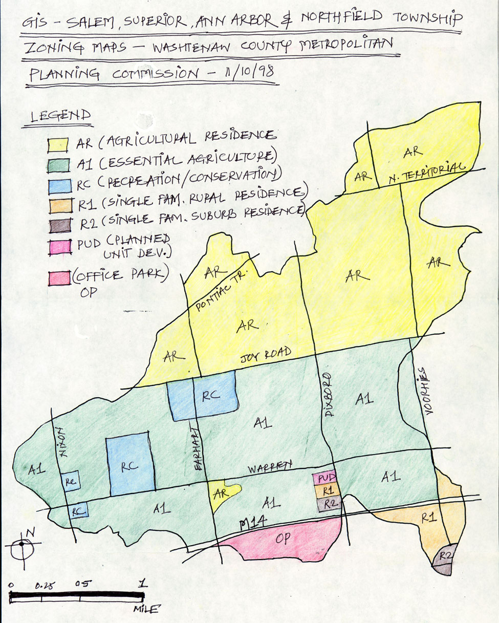
MAP 1: (GIS) Salem, Superior, Ann Arbor and Northfield Township Zoning Maps:
This map was generated by extracting zoning information from the four different township maps. I wanted to use the local zoning guidelines to my advantage, as far as possible. This map gave me an understanding of what was the preferred zoning adopted by the four governing bodies and analyze later whether they needed to be changed or revised as per my land use design proposal. Some of the salient features of the zoning map are,
The entire area of the watershed on the north of Joy Road is zoned AR - Agricultural Residential.
The area between the highway M-14 and Joy Road is zoned A1 – Essential Agricultural.
There are some pockets of RC (Recreation/Conservation), R1 (Single Family Rural Residence), R2 (Single Family Suburban Residence) and PUD (Planned Unit Development) in this area.
The southern part of the watershed below M14 is zoned OP (Office Park).
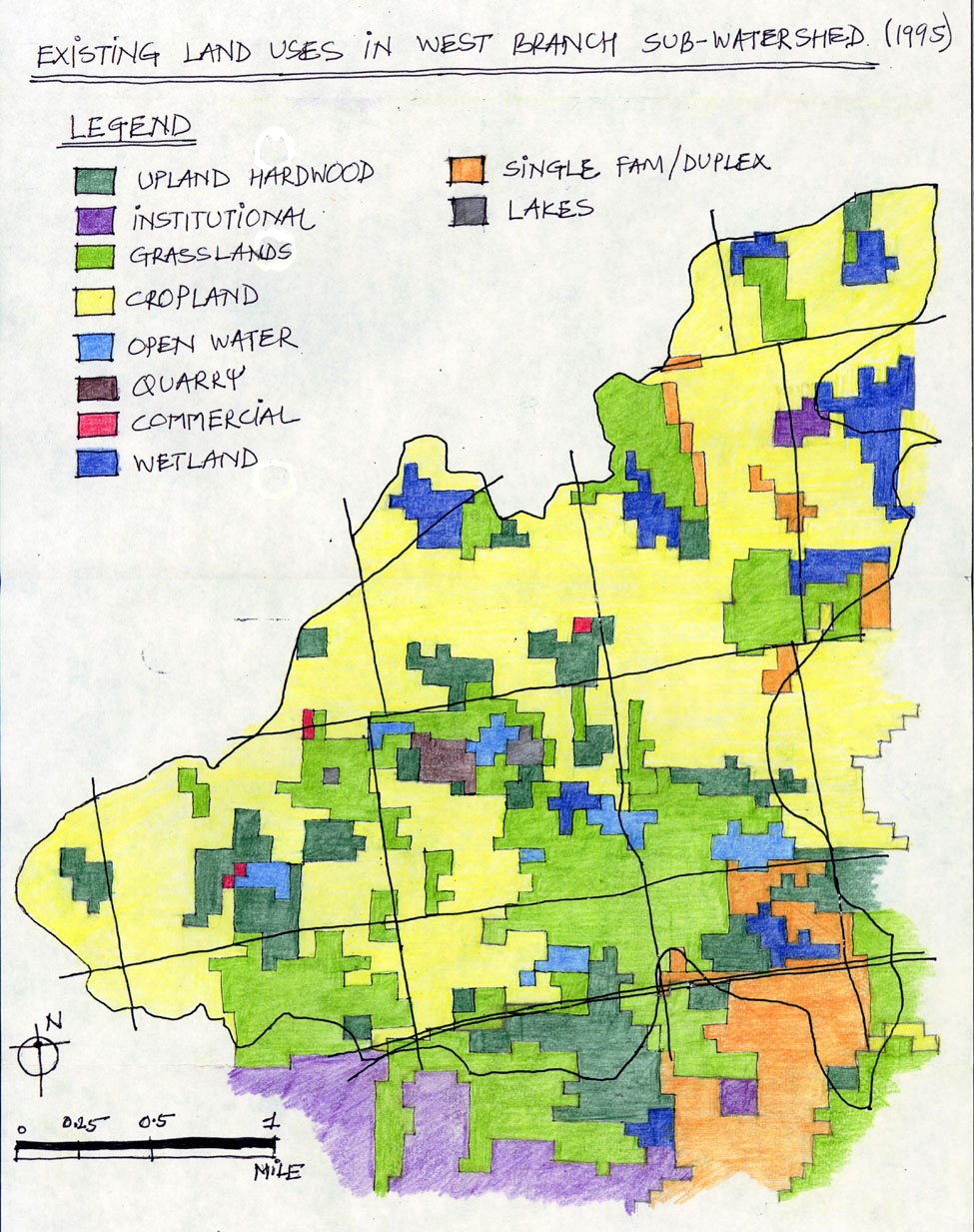
MAP 2: Existing Land Uses in West Branch Watershed:
This supplied map gave a clear overview of how the land in the watershed is currently used, what are the different uses and their relative proportion of areas and intensity. There is found a general variety of land uses in the area including upland hardwoods, grasslands, croplands, open water, wetlands, few lakes and institutional sites.
An important feature to note here is that the land use is so generally expanded that there is a lack of single prominent land use in a substantial size and area except for the cropland, which joins all the other land uses. The land uses are evenly spread all over the watershed and do not present any specific pattern. I was unable to get any definite design concept through this land use plan and hence I decided to shift to the next map rather quickly.
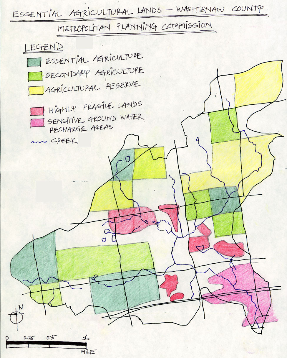
MAP 3: Essential Agricultural Lands:
This map was also generated by extracting land quality information pertaining to the watershed area from a larger map. It gave a detailed layout of the different types of land quality features. Some of the salient features are,
Essential agriculturally suitable land is mostly situated in the southern part of the watershed area.
Secondary agriculturally suitable land is located in the southern and eastern part of the watershed area.
Large chunks of agricultural reserved land are located in the northern part of the watershed area.
Highly fragile land is concentrated at the center of the watershed area between Warren and Joy Road stretching towards the east. This land includes the Nature Reserve area identified in the inventory list.
Sensitive ground water recharge area is located at the southeastern tip of the area across the M14 highway.
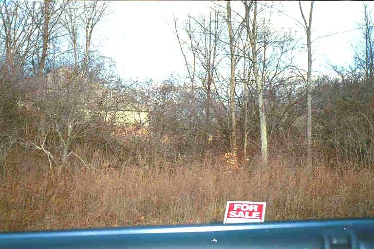
Market for properties on sale already up even as development gets finished early.
III: Land Use Development Plan:
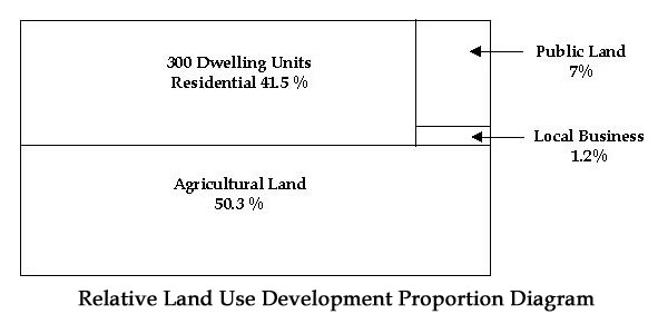
The following program for development was required at the minimum.
Required Land Use Program: Land Use Amount Description Agricultural 600 Acres Including large farms, small niche farming enterprises and other agricultural endeavors such as tree farms, u-pick operations, etc. Public Land 80 Acres Local park(s), including passive and active recreation Local Business 15 Acres Neighborhood services: grocery, café, day care, etc. Housing 300 Dwelling Units Rural Residential (10 acre parcels)
Single Family Dwelling (5 acre min. lot size)
Single Family Dwelling (2 acre min. lot size)
Single Family Dwelling (1/2 acre min. lot size)
Two Family Dwelling (4 dwelling units per acre)
Townhouse Dwelling (6 dwelling units per acre)
Mobile Home Park (10 dwelling units per acre)
As per the above information, a table was created consisting of simple values for each of the development (in terms of their relative hectare(age) and the total area for the minimum proposed development.
Regarding requirements for proposed minimum housing I used the following relative percentages of development units. In order to control sprawl, I wanted to discourage expansive residential lots. Keeping in mind the existing rural residential environment, I set a maximum of 10 % for this number of development units. I gave the single-family dwelling units a total of 25 % weigh. To foster strong community relationships and dense developments, I really wanted to concentrate on two-family dwellings and townhouses. I gave them together a large chunk of the required development units (60 %). Mobile park homes were set to just 5 % of the total development units.
Table showing Residential Acreage Calculation: Housing Unit Percentage Development Units Rate Acreage Rural Residential 10 % 30 10 Acres 300 Single Family Dwelling 5% 15 5 Acres Min. 75 Single Family Dwelling 10% 30 2 Acres Min. 60 Single Family Dwelling 10% 30 1/2 Acre Min. 15 Two Family Dwelling 30% 90 4 Dwellings/acre 23 Townhouse Dwelling 30% 90 6 Dwellings/acre 15 Mobile Home Park 5% 15 10 Dwellings/acre 1.5 Total 100 % 300 489.5
Table of Proposed Areas for Land Use Development: Land Use Acres Hectares Agricultural 600 273 Public Land 80 37 Local Business 15 7 Housing 300 D.U. 489.5 223 Total 1184.5 540
All are mud packed roads, except Dixboro, N. Territorial and Pontiac Trail.
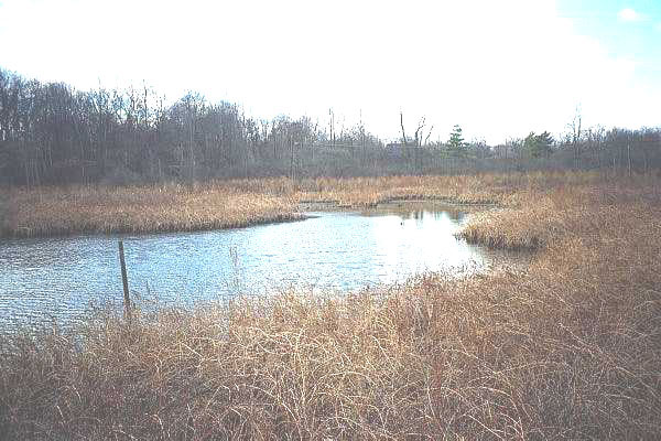
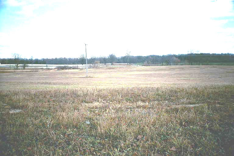
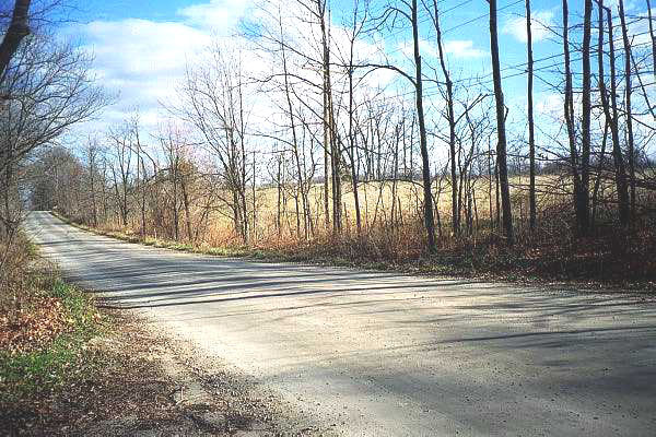
"Nature Reserve" on Warren Road. Highly sensitive ground water recharge area !
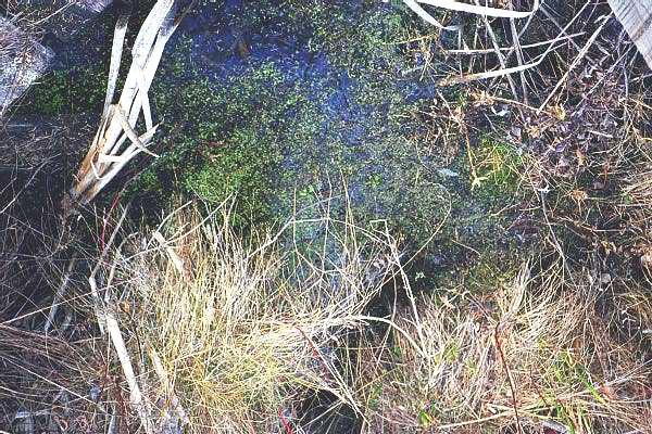
"Nature Reserve" on Warren Road. Note the watershed floor !
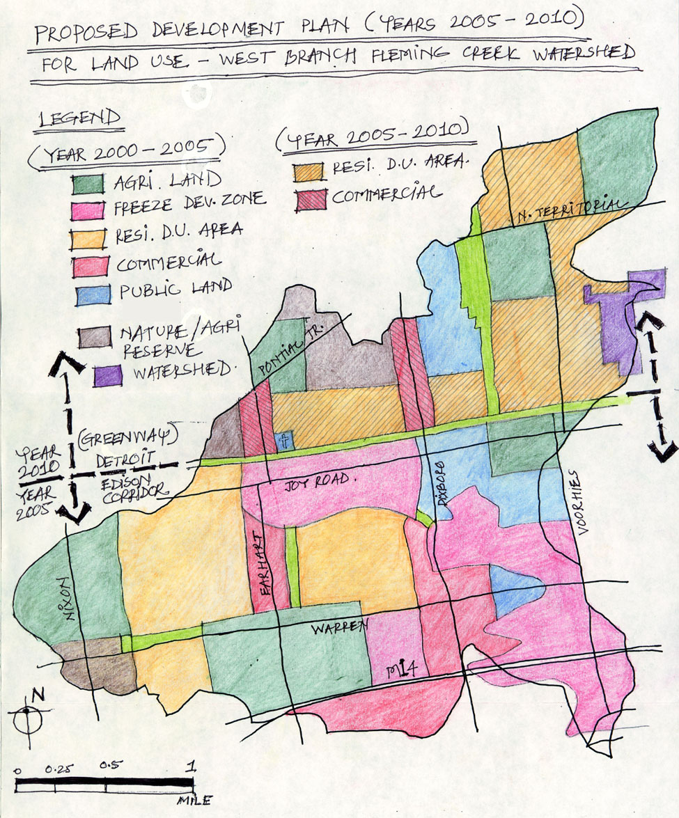
MAP 4: Proposed Land Use Development Plan (years 2000 to 2010):
Map 3 was instrumental in initiating the final land use design process. Another driving force was to control sprawl as much as possible. This would be achieved by concentrating development on the south side of the watershed area, which has already seen large-scale development close to M14 highway. The development would then be left to expand to northern areas in future, as needed. The concept of two five-year development intervals, which talk about these development trends, is discussed in detail in the first section of Growth Management Strategies. I used the following land uses in the shown order of merit.
Agricultural Land Use:
Because of the dwindling number of agriculturally productive lands all over the county, it was necessary to identify and preserve useful agricultural lands in their present locations. This land is preserved in the southern and southwestern part of the watershed area as per required acreage in the program schedule. More agricultural land is preserved up north as well. The total agricultural land preserved in the entire watershed area (both five-year intervals) is close to 1050 acres for the ten-year period.
Freeze Development Zone:
A Freeze Development Zone (FDZ - new coined) is immediately proposed to protect and preserve highly fragile lands and sensitive ground water recharge areas that are under threat for unhealthy developments. These developments include the quarrying operations of the Washtenaw Sand and Gravel Inc., at the intersection of Joy Road and Earhart Road. A buffer of minimum half-mile width is further created all around this combined fragile land. The total land preserved in the Freeze Development Zone is close to 750 acres and is untouched by the proposed development.
Residential Land Dwelling Unit Area:
This combined residential area consisting of all the required dwelling units proposed in between the areas of protected agricultural and freeze development zones over the cropland land use. These dwelling units are further broken into smaller communities (as per their acreage strength) through a system of interconnecting greenways. These greenways provide a way to connect frozen development land and recreational lands to agricultural lands through the community. The extent of the proposed development for the first five years is limited to the Detroit Edison electrical corridor just north of Joy Road, which would also be used as a greenway. The combined acreage provided to residential dwelling units is close to 500 acres in the first five-year interval.
The design guidelines for the denser (townhouses and two-family dwellings) residential communities will encourage "clustered" design of community housing, so that the varied locations of the existing woodlands, grasslands and wetlands are accommodated in the overall plan. These areas will be used to form larger interconnecting open spaces, which the entire community can enjoy. Septic tanks for single-family dwellings and common sewers systems for denser dwellings shall avoid watershed and creek areas within the residential areas.
Introduction of Bio-Gas Treatment Plants:
Since the use of septic tank is a matter of much concern, much so in the sensitive watershed area, I would like to introduce at this point, the concept of Bio-Gas Treatment Plant technology which has proved to be a grand success in rural India.
The Bio-Gas Plant Technology is a very commonly used technique of recycling and waste treatment that is adopted in rural India. In this technique, the entire organic waste of the village of large-scale development is channeled into an underground retention basin. This basin is made out of thick concrete walls that are treated for anti-seepage problems. All the human and animal waste is collected into this basin. Later natural fertilizers like earthworms, bacteria and nitrogen-based compounds are added to this mixture and the basin is untouched for 6 months. In the six months (in the accelerated process of decay), natural fertilizers break down the organic waste into manure and generate Methane gas as a by-product. This Methane gas is piped and used in households for cooking purposes.
Commercial Land Use:
Dixboro Road, which is a paved road, offers excellent opportunities for developing into a commercial area for the watershed. In addition, Earhart Road also promises to command a good commercial pull in future. Hence the major commercial activity is concentrated around these two roads running in north-south direction. Furthermore, service and daily needed shops are allowed to come up in the residential areas depending upon their conformity to development guidelines. The overall commercial acreage in the first five-year interval is close to 300 acres providing a good stability.
The concept behind mixing commercial areas with residential areas, is the need to make residential areas lively during day times. Conversely, residential areas help support commercial areas better by providing a good and constant consumer base.
Public Land Use:
Public land is set to the central-eastern part of the watershed area between the fragile lands and protected agricultural lands. It is also stipulated in the northern part of the corridor in the second phase. The present area in the first phase is calculated at 250 acres.
Nature/Agricultural Reserve and Watershed Areas:
These areas are interspersed with agricultural and over secondary agricultural lands as per the Essential Agricultural Lands map. These lands will serve as reserves for practicing agriculture in future as the need arises. The total area stipulated for these areas is close to 400 acres.
Land Acquisition and Purchase:
It has been observed from the supplied Platted Survey Map that Domino’s Farms Holding and D. F. Holding Ltd. Partnership hold together the largest amount of land in the watershed area. For the proposed development to go ahead, these owners should be offered up-zoning/rezoning opportunities so that they are able to develop their land. The Townships governing bodies can engage in talks and offers to buy smaller properties on the east side to bring some land under their control. This could be achieved by offering these property owners incentives (in taxes) to develop their lands at other locations.
V. Growth Management Strategies for the area:
The growth management strategies for the area are categorized into the following sections.
A. Anticipating Future Development Needs (10 years):
We understand fully well that the development process never subsides. More and more land is needed every year for development uses, working within the raising demands of an ever-increasing population. Ann Arbor and its surrounding areas are definitely showing a tremendous surge in population due to their good and strong economic base.
I have used two five-year interval periods for the twin phase development process. The first phase involves the required minimum land use program requirement. This phase is set for five years from years 2000 to 2005. In this phase the entire current development is restricted to south of the existing Detroit Edison electrical supply corridor used as a greenway. This corridor will create a visual boundary to the proposed development. The area is sufficient to accommodate the present development requirements.
The next five-year interval is designed for years 2005 to 2010. This future scope of development is designed to absorb the rise in population and development needs beyond the next five years. The development guidelines will be set in such a way that the land stipulated for the second five interval period shall not be used until the land for the previous interval period has been fully and efficiently utilized.
B. Preserving Agriculture Lands by Purchase of Development Rights (PDR):
Agriculture lands should be preserved for producing crops and should not be wasted in developments. These lands are too precarious to be lost in the development race. Similar steps should be taken to preserve fragile and sensitive and water recharge lands. In the event of Highest and Best Use mode of property taxation, the city should offer to purchase the farmer’s development rights. This will also ensure the farmers that their agricultural land is not taxed to its maximum potential.
C. Promote High-Density Residential Use by Up/Rezoning or Offering Transfer of Development Rights (TDR):
The proposed residential dwelling areas should be encouraged towards denser development by up-zoning or rezoning current private properties. Another option could be to offer these properties Transfer of development Rights from nearby agricultural lands who are willing to sell. This will also avoid the city from being forced to step into purchasing development rights from farmers.
D. Using Conservation Easements For Greenway Connections Between Preserved And Recreational Lands:
Conservation Easements should be used to get access to private properties so that greenways are able to connect different open and green spaces and preserved lands. Conservation easements do not seriously undermine the rights of the property owner, but allow for some usage of that persons land for greenways. In return the owner can be offered tax incentives for this social cause.
VI. Sources of Maps:
GIS Salem, Superior, Ann Arbor and Northfield Township Zoning Maps prepared by the Washtenaw County Metropolitan Planning Commission 11/10/98. Updates on Parcels (1998) and Zoning (November 1998).
Washtenaw County Rural Development Policies, July 8, 1981.
Essential Agricultural Lands – Washtenaw County Metropolitan Planning Commission.
Existing Land Uses in West Branch Watershed Area, 1995.
Platted Survey Map of the Watershed Area.